Sunday, March 23, 2014

HUGE Tropical Cyclone Gillian Heads Towards Offshore Australia Shores!!!!! Enormous Eye!!! GUSTS = 135 Knots!!!, NOW a CAT-5!!!

I just discovered this HUGE Tropical Cyclone and am posting it here mostly for information related to the search for the plane in the Indian Ocean. There is NOW a Huge Tropical Cyclone heading directly for the same area!!! Just seen it posted as a CAT-5, Now!!! First, here is the main story due to the fact it has already struck at Christmas Island about a thousand miles north of Perth! You may wish to skip ahead and just check out those awesome pics. . . but here's the story: http://www.smh.com.au/national/tropical-cyclone-gillian-hits-christmas-island-20140322-359ou.html AND Here is the page dedicated to Tropical Cyclone #17, Gillian at Hurricane Zone.net: http://www.hurricanezone.net/#17p

Now the pics, first a huge overall shot showing the current location as of Sunday Morning as I am writing this give or take just a few hours:
AND HERE is a Great shot of what it looks like from above in a Close-Shot:

The forecast appears to show it heading directly into the region where they are searching!!! @
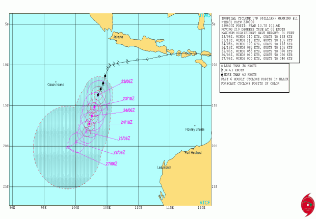
Finally I copied all the forecast information from the above Hurricane Zone Page and will paste all of it at the end of this blog entry. All of this will only be valid through Sunday, March 23, 2014 as new forecasts will be updated beginning throughout the day and of course into Monday. That link above may update, though! Thank-You for Reading!!! EQ Guy


WTXS31 PGTW 230900
MSGID/GENADMIN/JOINT TYPHOON WRNCEN PEARL HARBOR HI//
SUBJ/TROPICAL CYCLONE 17P (GILLIAN) WARNING NR 011//
RMKS/
1. TROPICAL CYCLONE 17P (GILLIAN) WARNING NR 011
01 ACTIVE TROPICAL CYCLONE IN SOUTHIO
MAX SUSTAINED WINDS BASED ON ONE-MINUTE AVERAGE
WIND RADII VALID OVER OPEN WATER ONLY
---
WARNING POSITION:
230600Z --- NEAR 13.7S 103.6E
MOVEMENT PAST SIX HOURS - 210 DEGREES AT 08 KTS
POSITION ACCURATE TO WITHIN 020 NM
POSITION BASED ON EYE FIXED BY SATELLITE
PRESENT WIND DISTRIBUTION:
MAX SUSTAINED WINDS - 110 KT, GUSTS 135 KT
WIND RADII VALID OVER OPEN WATER ONLY
RADIUS OF 064 KT WINDS - 035 NM NORTHEAST QUADRANT
040 NM SOUTHEAST QUADRANT
040 NM SOUTHWEST QUADRANT
035 NM NORTHWEST QUADRANT
RADIUS OF 050 KT WINDS - 065 NM NORTHEAST QUADRANT
070 NM SOUTHEAST QUADRANT
070 NM SOUTHWEST QUADRANT
065 NM NORTHWEST QUADRANT
RADIUS OF 034 KT WINDS - 110 NM NORTHEAST QUADRANT
120 NM SOUTHEAST QUADRANT
115 NM SOUTHWEST QUADRANT
105 NM NORTHWEST QUADRANT
REPEAT POSIT: 13.7S 103.6E
---
FORECASTS:
12 HRS, VALID AT:
231800Z --- 15.2S 103.0E
MAX SUSTAINED WINDS - 110 KT, GUSTS 135 KT
WIND RADII VALID OVER OPEN WATER ONLY
RADIUS OF 064 KT WINDS - 035 NM NORTHEAST QUADRANT
040 NM SOUTHEAST QUADRANT
040 NM SOUTHWEST QUADRANT
035 NM NORTHWEST QUADRANT
RADIUS OF 050 KT WINDS - 060 NM NORTHEAST QUADRANT
070 NM SOUTHEAST QUADRANT
070 NM SOUTHWEST QUADRANT
060 NM NORTHWEST QUADRANT
RADIUS OF 034 KT WINDS - 110 NM NORTHEAST QUADRANT
120 NM SOUTHEAST QUADRANT
115 NM SOUTHWEST QUADRANT
105 NM NORTHWEST QUADRANT
VECTOR TO 24 HR POSIT: 200 DEG/ 06 KTS
---
24 HRS, VALID AT:
240600Z --- 16.3S 102.6E
MAX SUSTAINED WINDS - 100 KT, GUSTS 125 KT
WIND RADII VALID OVER OPEN WATER ONLY
RADIUS OF 064 KT WINDS - 025 NM NORTHEAST QUADRANT
030 NM SOUTHEAST QUADRANT
030 NM SOUTHWEST QUADRANT
025 NM NORTHWEST QUADRANT
RADIUS OF 050 KT WINDS - 050 NM NORTHEAST QUADRANT
060 NM SOUTHEAST QUADRANT
060 NM SOUTHWEST QUADRANT
050 NM NORTHWEST QUADRANT
RADIUS OF 034 KT WINDS - 100 NM NORTHEAST QUADRANT
110 NM SOUTHEAST QUADRANT
105 NM SOUTHWEST QUADRANT
095 NM NORTHWEST QUADRANT
VECTOR TO 36 HR POSIT: 200 DEG/ 05 KTS
---
36 HRS, VALID AT:
241800Z --- 17.3S 102.2E
MAX SUSTAINED WINDS - 085 KT, GUSTS 105 KT
WIND RADII VALID OVER OPEN WATER ONLY
RADIUS OF 064 KT WINDS - 020 NM NORTHEAST QUADRANT
020 NM SOUTHEAST QUADRANT
020 NM SOUTHWEST QUADRANT
020 NM NORTHWEST QUADRANT
RADIUS OF 050 KT WINDS - 040 NM NORTHEAST QUADRANT
050 NM SOUTHEAST QUADRANT
050 NM SOUTHWEST QUADRANT
040 NM NORTHWEST QUADRANT
RADIUS OF 034 KT WINDS - 090 NM NORTHEAST QUADRANT
100 NM SOUTHEAST QUADRANT
095 NM SOUTHWEST QUADRANT
085 NM NORTHWEST QUADRANT
VECTOR TO 48 HR POSIT: 210 DEG/ 05 KTS
---
EXTENDED OUTLOOK:
48 HRS, VALID AT:
250600Z --- 18.2S 101.7E
MAX SUSTAINED WINDS - 055 KT, GUSTS 070 KT
WIND RADII VALID OVER OPEN WATER ONLY
RADIUS OF 050 KT WINDS - 030 NM NORTHEAST QUADRANT
040 NM SOUTHEAST QUADRANT
040 NM SOUTHWEST QUADRANT
030 NM NORTHWEST QUADRANT
RADIUS OF 034 KT WINDS - 080 NM NORTHEAST QUADRANT
090 NM SOUTHEAST QUADRANT
085 NM SOUTHWEST QUADRANT
075 NM NORTHWEST QUADRANT
VECTOR TO 72 HR POSIT: 230 DEG/ 05 KTS
---
72 HRS, VALID AT:
260600Z --- 19.5S 100.1E
MAX SUSTAINED WINDS - 040 KT, GUSTS 050 KT
WIND RADII VALID OVER OPEN WATER ONLY
DISSIPATING AS A SIGNIFICANT TROPICAL CYCLONE OVER WATER
RADIUS OF 034 KT WINDS - 070 NM NORTHEAST QUADRANT
080 NM SOUTHEAST QUADRANT
075 NM SOUTHWEST QUADRANT
065 NM NORTHWEST QUADRANT
VECTOR TO 96 HR POSIT: 240 DEG/ 04 KTS
---
LONG RANGE OUTLOOK:
---
96 HRS, VALID AT:
270600Z --- 20.2S 98.7E
MAX SUSTAINED WINDS - 030 KT, GUSTS 040 KT
WIND RADII VALID OVER OPEN WATER ONLY
DISSIPATED AS A SIGNIFICANT TROPICAL CYCLONE OVER WATER
---
REMARKS:
230900Z POSITION NEAR 14.1S 103.5E.
TROPICAL CYCLONE (TC) 17P (GILLIAN), LOCATED APPROXIMATELY 790 NM
NORTHWEST OF LEARMONTH, AUSTRALIA, HAS TRACKED SOUTH-SOUTHWESTWARD
AT 08 KNOTS OVER THE PAST SIX HOURS. ANIMATED MULTISPECTRAL
SATELLITE IMAGERY (MSI) REVEALS TC GILLION HAS CONTINUED TO RAPIDLY
DEEPEN INTO AN INTENSE SYSTEM AS THE CONVECTION HAS IMPROVED AROUND
A 15NM SLIGHTLY IRREGULAR EYE. A 230305Z TRMM MICROWAVE IMAGE SHOWS
A THICK RING OF DEEP CONVECTION IN THE EYEWALL WITH IMPROVED BANDING
IN ALL QUADRANTS. THE INITIAL POSITION IS BASED UPON THE EYE FEATURE
IN THE MSI LOOP WITH HIGH CONFIDENCE. THE INITIAL INTENSITY HAS BEEN
INCREASED TO 110 KTS BASED ON AVERAGE OF DVORAK INTENSITY ESTIMATES
THAT RANGE FROM 102 TO 115 KNOTS. UPPER-LEVEL ANALYSIS REVEALS A
FAVORABLE ENVIRONMENT AS A POINT SOURCE ANTICYCLONE HAS DEVELOPED
OVER THE SYSTEM WHICH IS PROVIDING LOW (05 TO 10 KNOTS) VERTICAL
WIND SHEAR (VWS) AND VIGOROUS POLEWARD AND EQUATORWARD OUTFLOW. TC
17P IS CURRENTLY TRACKING POLEWARD ALONG THE NORTHWESTERN PERIPHERY
OF A DEEP-LAYERED SUBTROPICAL RIDGE (STR) THAT POSITIONED TO THE
SOUTHEAST OF THE SYSTEM. TC GILLION IS EXPECTED TO CONTINUE ALONG
THIS STR THROUGH TAU 36 UNTIL A WEAK MID-LATITUDE TROUGH WELL TO THE
SOUTH WILL SLIGHTLY WEAKEN THE STR AND CAUSE THE CYCLONE TO SLOW
DOWN. AFTER TAU 24, A WEAKENING TREND IS EXPECTED TO BEGIN AS VWS
INCREASES FROM THE APPROACHING TROUGH. AFTER TAU 48, A SECONDARY STR
TRAILING THE TROUGH, WILL BUILD TO THE SOUTHWEST AND BEGIN TO MOVE A
WEAKENING TC 17P WESTWARD. VWS WILL GREATLY INCREASE AFTER TAU 48 AS
THE SYSTEM SWITCHES STEERING INFLUENCES AND WILL INDUCE A RAPID
WEAKENING TREND WHICH WILL DISSIPATE THE SYSTEM BELOW WARNING
THRESHOLD BY TAU 96. NUMERIC MODEL GUIDANCE IS SLIGHTLY SPREAD, BUT
WITH THE EXCEPTION OF COAMPS-TC AND NAVGEM, GENERALLY SUPPORTS THE
WESTWARD TRACK IN THE EXTENDED PERIOD. DUE TO THIS, THE JTWC
FORECAST TRACK IS POSITIONED CLOSE TO MULTI-MODEL CONSENSUS WITH LOW
CONFIDENCE. MAXIMUM SIGNIFICANT WAVE HEIGHT AT 230600Z IS 31 FEET.
NEXT WARNINGS AT 232100Z AND 240900Z.//

Friday, January 24, 2014

EQ Podcast #001

My Very First Podcast!!!!! Check It Out!!! Click Arrow!!!
Thank-You For Listening!!!!! EQ Guy

Monday, November 11, 2013

BIG EQ ALERT: BANGKOK, BANGLADESH, CHINA, INDONESIA!!! 7.9 to 9.1 RICHTERS!!!

This will be the next huge earthquake that strikes a fairly large area somewhere, although hopefully it will be a far less populated area without nearly the damage it could possibly do. There is also currently a similar alert that covers a lot of the same regions in the 7.6 to 8.1 Range and is on Day 31 as of November 11, 2013. THIS New EQ Alert will begin immediately and run through Mid-December.

The maximum windspeeds of Super Typhoon Haiyan were reported at 195 with gusts having been reported as high as 235mph by the JTWC prior to the landfall. Winds at landfall and beyond are being reported at 147 with gusts at 170 and it is probable there is not much difference there except that the amount of the higher numbers that were once reported also contribute to generating Major Earthquake Energy and as a result give us that highest estimated magnitude of 9.1 Richters.

The straight line from the landfall at Philippines heads directly across Thailand, Cambodia, Myanmar, Bangladesh, and Bangkok, but the entire tectonic plate boundary will also include up into China, Nepal, and a few other countries, and also south to Indonesia and the Andaman and Nicobar Islands Region. There has also now been a lot of shaking in the wake of that landfall, too, including one at Micronesia, and two very recent ones early today, November 11, 2013 at North of Taiwan, and Mariana Islands which looks like it's very near that Mariana Trench and all just 1500 or 2000 miles due east of the landfall of Super Typhoon Haiyan at Philippines.

The rule that I like to use and have written about in books and blogs, is that with the Major Earthquake Resultant expected after the landfall of a Huge Windstorm the damage will generally be about 90% of the damage done by the windstorm! In this case the damage from Super Typhoon Haiyan is now very extensive. . . and so we will be watching for the next huge Major Earthquake with damage similarly extensive and probably one comparable to what the Philippines is presently undergoing with Philippines even being very much in the crosshairs of this potential earthquake due to having just had a Major Earthquake in recent weeks and possibly being due for a Major or even larger aftershock near Cebu City.

There may be two of these gigantic sized Major Earthquakes due to strike and on at least one or two occasions they have combined which these two hopefully will not do. The Philippines also have a number of Major Volcanoes and as a result we might also expect some Volcano Activity, too! Thank-You For Reading!!! EQ Alert Guy

Wednesday, September 18, 2013

OFFICIAL PREDICTION FOR A MAJOR EARTHQUAKE TO STRIKE ANCHORAGE, JUNEAU, HELENA, OR NEW MADRID BY OCTOBER 22, 2013

This brand new now upcoming Major Earthquake will probably be in the area of 6.7 or 6.8 Richters but could go as big as a 7.6 Richters. The area of uncertainty in magnitude is as a result of Typhoon Man-Yi losing strength as it approached landfall at Honshu Japan and the amount of possible seismic energy it could have generated in that approach in shallower waters and outlying islands as well as outer bands reaching land sooner, added to the total amount contacting the tectonic plate on land during Man-Yi’s landfall there.

There is also a Major Earthquake due to strike as soon as September 20 through 23 as a result of the landfall of big CAT-4 Super Typhoon Utor at the Philippines on August 11, 2013 which could possibly strike in the early days of this O.P. and could coincide with the September 2013 Full Moon Window of September 18 through September 20 and so a big South or Central America Earthquake of 7 or 8 Richters will not come under this Official Prediction if and when one does strike at any place other than those covered by this writing.

I had a similar Official Prediction written on October 14, 2012 that crossed a similar path and I stated Edmonton in that writing. . . . . and the huge climax actually occurred at Queen Charlotte Island just 13 days later at 7.7 on October 28, 2012. You can view that Official Prediction @ http://www.earthquakealert2.blogspot.com/2012/10/official-earthquake-prediction.html AND the USGS report on that Queen Charlotte Earthquake @ http://earthquake.usgs.gov/earthquakes/eqinthenews/2012/usb000df7n/

You could say that due to just the above rather recent incident regarding Jelawat, that we might know the landfall of Typhoon Man-Yi will probably now precede a quite similar Major Earthquake and possibly in that same region. One slight difference being the winds reported with Typhoon Jelawat at 100mph and Typhoon Man-Yi at 75, but you could also say that 75 percent of that 7.7 at Queen Charlotte might also still be a huge earthquake.

This straight line of brand new potential earthquake energy or seismic energy will now somewhat duplicate the path of the energy from that landfall of Typhoon Jelawat very near to where this recent landfall of Typhoon Man-Yi occurred. You can view the path of Jelawat at: http://en.wikipedia.org/wiki/File:Jelawat_2012_track.png and looks like it could stay south of the Denali Fault. I’m not sure which side of the Denali Fault Jelawat traveled but am reasonably sure todays path will be traveling south of it and the banner headline from the Jelawat O.P. says Fairbanks. Todays line crosses very near Anchorage and goes on to cross near the epicenter of 1964 Alaska Earthquake, then onto Juneau, Helena, and finally New Madrid and while I do not expect it to vary too much from this exact line, it does appear Queen Charlotte Island is situated a few miles west of the exact line of that October 14, 2012 O.P.

Today I am putting the final end date of all of this new earthquake energy at October 22, 2013, although a lot could happen in the days in between and those regions of Alaska that are situated closer to the Japan Landfall will be first along the line to possibly be affected. There is also as I write, an immediate chance Japan might get some of this earthquake energy as a result of all of the energy from this big windstorm pushing against Shikoku and Honshu and there was already a 5.1 Richters Earthquake at Honshu in the hours after that landfall. There could be more and it will remain a possibility that Japan could be affected and receive up to the grand total of 7.6 Richters at some point throughout the duration of this Official Prediction.

Thank-You Again for taking the time to read this O.P. and Thank-You also for all the great comments I have been getting when these major earthquakes inevitably strike such as the recent ones at Peru, Easter Island, and Victoria!!! Respectfully Submitted, EQ Guy

Herein Submitted September 18, 2013

Tuesday, July 16, 2013

OFFICIAL PREDICTION FOR A MEGATHRUSTER MAJOR EARTHQUAKE AS BIG AS 9.3 RICHTERS TO STRIKE BEFORE AUGUST 31, 2013

The landfall of Typhoon Saulik at Northern Taiwan had gusts reportedly as high as 130mph and tracked straight across the very top of that island on a path that was virtually due West. Upon close checking with the World Atlas, I found that this brand new line of potential Major Earthquake energy crosses directly through a city by the name of Mandalay. The major fault line that it crosses right there at about that same point is also the one that extends south and might have been responsible for the 2004 Sumatra Earthquake. This Fault line also extends North from that point up into the region where the Sichuan, China Earthquake also struck.

Therefore, today I want to just post this "Official Prediction" although there is actually NO current such outlet that accepts such a prediction, post here for later reference such as after this Major Earthquake or possibly Mega-Thruster strikes. The range of this Major Earthquake should easily fall into the range of between 7.6 and 9.3 Richters and I will guess it at about 9.1 Richters. Mandalay, Bangladesh, and Myanmar will be first in line for this Major Earthquake Event and I must mention that Taiwan itself is getting Major Foreshocks as I am writing this and could also very easily become the epicenter of the earthquake energy that was generated right there on their island, so watch Taiwan as well as Alaska where they have now received like 275 Total Richters of Earthquake Swarms in the last day or so! Alaska and Japan are not exactly on this line, but are situated along the nearby tectonic plate boundaries you know! So would the Cascadia Fault be! In addition to Sichuan, China and Sumatra, and Indonesia being to the North and South and perhaps being susceptible to major earthquakes, there is also Guam, Hawaii, Lima Peru, New Delhi, Pakistan, Oman, UAE, Yemen, and South Iran that are all situated directly on this new line of potential MegaThruster Sized Earthquake Energy.

The landfall of a similar Super Typhoon Nanmadol in December of 2004 preceded the Sumatra Earthquake of 2004 and the landfall of Cyclone Nargis at Myanmar preceded the Sichuan Earthquake at Sichuan, China 10 days later. If the numbers on this event work out the same as the numbers in the Nargis/Sichuan event, then we will be watching for this Major Earthquake, Earthquake/Tsunami, or possibly Volcano Event to take place on or possibly before Monday, July 22, 2013 although the geography is nowhere near similar here and so the full timeline on this event will actually run all the way through August of 2013 with the final end date of this Official Prediction being August 31, 2013. That Day 10 mentioned above looks like it is not only a highly suspect date we will be watching on, but also appears to be the July 2013 Full Moon!!! As of this writing I have now had so many correlations between Major Earthquakes and Full/New Moons that I consider it highly probable now that there will at least be a Giant Foreshock that night as well as the 24 hour period before and after the exact moment of the Full Moon, which in July 2013 will be July 22, 2013 at 18:17 UTC or actually the very early hours of July 22 on the other side of the world, while being like 10:17am July 22 on our West Coast.

It has been quite some time since I have had to stare at the screen on the computer trying to type while knowing full well that hundreds of thousands of people might be killed in the coming moments and hours by a major earthquake event that myself and a lot of my best readers all knew about. Many of you up to this point have now seen many of these come and go and it is actually the very reason that a lot of you are reading this right now, because you have now personally viewed any number of these where you are reading the name of a city somewhere in the world one minute. . . and seeing that a major earthquake actually struck there the next. Of course it is now very common for me because I now do this all the time, but at some point I want you all to know I hope that we will some day have the ability somehow to let the people in other parts of the world to know times such as now when there could be a major earthquake heading for them! A lot of these people in a lot of these places are like me and you and could easily be sleeping out in tents so that they will not be sleeping in their houses when an earthquake strikes. Today, me and you know there will probably be a Major Earthquake striking very, very soon. . . in the future perhaps translating my EQ Blog into all the other different languages of the world could let these people know what is going on in the world of Earthquake Prediction and as I say in my new book I'm currently writing, together we might all be able to help in Bringing Earthquakes To Life!!!

Thank-You All Again For Reading!!!!!

Respectfully Submitted,
Les Brown, The EQ Alert Guy

Saturday, June 15, 2013

OFFICIAL PREDICTION FOR A MAJOR NORTHERN CALIFORNIA EARTHQUAKE OF ABOUT 7.0 RICHTERS BEFORE JULY 13, 2013

I want to begin today by saying that the Northern California Region that I will be discussing or NorCal, has come up in many of my past EQ Alerts and Official Predictions and that I have a history of what I might say is a high degree of accuracy when it comes to this region up around Eureka, California.

On the day of the Northridge Earthquake I researched all the things that preceded many other major earthquakes throughout history and found a lot of them were preceded by Major Hurricanes making landfall. Not long after that day Hurricane John was a Category 5 and came within 15 miles of Johnston Atoll in the Pacific Ocean on August 25, 1994. On an old typewriter I typed several letters and sent them to my friends in the Hollywood area telling them all I knew at the time was Hurricanes, such as Hurricane John, had been known to precede Major Earthquakes because I had only been researching this matter just over 6 months at the time. On September 1, 1994, seven days later a 7.0 Earthquake struck 70 Miles Offshore from Cape Mendocino, California and it became the first ever fairly accurate prediction albeit with no idea where it might have shook.

In the years since that very exciting episode in my years as The EQ Alert Guy, I have also sent out “EQ Alert: California” following the landfalls of Hurricanes Frances, Ivan and Jeanne on September 5, 16, and 25 of 2004 and a couple days later on September 28, 2004 the Parkfield Earthquake struck. I had also written a great EQ Alert in December of 2003 in the days prior to the Paso Robles Earthquake.

On December 22, 2009 I filed an Official Prediction with both the California Earthquake Prediction Evaluation Council and the National Council which featured the banner headline “OFFICIAL PREDICTION FOR A MAJOR EARTHQUAKE TO STRIKE CALIFORNIA BEFORE JANUARY 12, 2010.” You may view that @ http://earthquakealert.blogspot.com/2009/12/official-prediction-california-just.html
Then, on the evening of January 9, 2010 Eureka, California got a 6.5 Richters Earthquake 33 Miles Offshore from Eureka! Ironically the date I gave in the banner headline and a few days after the Eureka 2010 Earthquake was the Haiti Earthquake of January 12, 2010. I predicted that sort of movement of the North American Tectonic Plate and it is similar to todays story.

When Typhoon Roke made landfall at Japan on September 21, 2011 the line representing its path across that country led directly to Southern Oregon and Northern California. Someone on one of the EQ Blogs mentioned that the October 2011 Full Moon was to be on October 12. Since the full moon would be on about Day 21 after that landfall I immediately bought a ticket and flew out to San Francisco to “Quake Chase” this upcoming event! I also filed an Official Prediction with CEPEC and NEPEC dated September 22, 2011, in addition to delivering a copy by hand to CEPEC at USGS Menlo Park via Caltrain/BART with this headline, “OFFICIAL PREDICTION FOR A MAJOR EARTHQUAKE TO STRIKE EUREKA, CALIFORNIA BEFORE OCTOBER 21, 2011.” On the day I arrived, the day before the full moon or October 11, 2011. You can that O.P. @ http://earthquakealert.blogspot.com/2011_09_01_archive.html Today I refer to that trip to San Francisco as “Quake Chase 2011” and I personally consider it the very first ever successful Quake Chase because at 8:15pm on the night of that October 2011 full moon of October 12, 2011 there was a 5.9 Richters Earthquake Offshore from Coos Bay, Oregon which shook the neighborhood I was staying in Daly City, although it was later downgraded to a 5.3, here is that story @ http://www.anzavalleyoutlook.com/story/62541/

Regarding the Official Prediction that I am filing herein, the winds associated with the recent EF-5 Tornado at El Reno, Oklahoma on May 31, 2013 were reported as high as 250 Mph. When I tracked the line of potential seismic energy that this huge tornado would leave behind, I immediately noticed Northern California again. However I also tracked it veering Southeast and discovered some additional shaky places and the June New Moon was quickly approaching on that date, too. It was only days after that tornado that I discovered all of this and wrote out an EQ Blog Entry for Antiqua & Barbuda with the following headline, “ New Moon Window Begins 9am Friday! ADD: Antiqua, Barbuda, Dominica & Montserrat to EQ Alerts!” You can view that EQ Blog @ http://earthquakealert.blogspot.com/2013/06/new-moon-window-begins-9pm-friday-add.html

Early that Sunday Morning, June 9, 2013 and within the June New Moon Window, Antiqua received a 3.8 Richters Earthquake just 2 miles East of the Island of Antiqua. Also shown in a Digital EQ Alert, link in next paragraph.

That was the direction of the path on the ground of the El Reno Tornado. In the Digital EQ Alert video I produced covering this topic @ http://earthquakealert.blogspot.com/2013/06/antiqua-shook-will-northern-california.html
You will notice the I have drawn this line in both directions because it became common over the years for earthquakes to happen in either direction from the biggest such windstorms, possibly due to the vortex having winds that reciprocate. Therefore today it is my opinion that the success I achieved with Antiqua, could become the next big Northern California Earthquake this time of 2013 before July 13, 2013. I will leave my guess as to the size of this possible shaker same as the headline, or 7.0, but of course it could range anywhere from a 6.6 up to a 7.6 or so. Occasionally some people like to guess the exact size, so 7.0 for my exact guess based on my very first such success back in 1994.

Hurricane Barbara’s landfall at Mexico on May 29, 2013 caused me to write an EQ Blog that could possibly have also been yet another O.P. for New Madrid, Illinois, and Chicago. I know it might not sound like much, but they just got a 2.4 North of Blytheville, Arkansas tonight and it has been a very long time since the New Madrid Region has had much shaking at all. That’s now twice I consider myself correct in less than a week, it also now possibly means there is still an Illinois or Chicago Earthquake coming for up to 5 Magnitude, yet. Please make a note of that.

I also have to have one final extension for my Official Prediction for the region South of Los Angeles through July 3, 2013 when it should virtually run out and will have struck either that region, Hawaii or out to sea beyond there by then, and hopefully unnoticed.

Thank-You Again!!!
Respectfully,
The EQ Alert Guy