[On May 10, 2014, I filed an Extension By Letter for this Official Prediction now through June 1, 2014. You can view that at my EQ Blog@ http://earthquakealert.blogspot.com/2014/05/55-strikes-113-miles-southwest-of.html ]
It is more or less common knowledge that the Pacific Tectonic Plate moves towards the north along the edge of the North American Tectonic Plate. In recent days this movement was indicated by several earthquakes along the eastern edge of the Pacific. Most Notably and in order both chronologically as well as from south to north, they are 8.2 Chile, 6.6 Nicaragua, 7.5 Mexico and as of yesterday, April 24, 2014, a 6.6 at Vancouver Island, Canada.
The latter in the series received much discussion in the days before it occurred due to Chile, Nicaragua, and Mexico shaking in that order also more or less as predicted. Chile had also been in an EQ Blog under the heading “Next MegaThruster/Tsunami Could Be Coming” immediately before it shook and in a Twitter message as well. Here is a link to that EQ Blog entry: http://earthquakealert.blogspot.com/2014/04/new-moon-alert-ends-but-next.html
Therefore it seems necessary now to submit this Official Prediction to the National Earthquake Prediction Evaluation Council strictly for the purpose of noting that there should be a Major Earthquake in the range of 6.6 to 8.9 at or near the Denali Fault and very near the City of Anchorage, Alaska and well within the State of Alaska probably well before May 10, 2014 and very likely in the hours and days that will immediately follow the submission and posting of this Official Prediction. It seems most likely Anchorage and Alaska will shake at some point during the April 2014 New Moon Window of April 28 at 6:18 UTC through April 30 at 6:18 UTC if not before then. If this earthquake or series of earthquakes has not commenced by the final moments of the month of April 2014, then it will continue to remain likely into the very early hours and days of May 2014.
This type of occasional movement of the Pacific Tectonic Plate seems as though it is being fairly predictable at least on occasions such as this where it is exhibiting a circular motion thus resulting in the movement against the North American Tectonic Plate that it is rather famous for and has more than been established historically. You could say that if and when Anchorage does get this earthquake that when such a situation arises in the future we might alert people in the region around the Denali Fault. Not to mention those other areas where earthquakes actually struck this time as well as possibly areas such as, but not limited to, Los Angeles and San Francisco who have as of this writing not been directly affected by this particular movement of the Pacific Tectonic Plate.
Thank-You For Accepting this Official Prediction. Respectfully, EQ Guy
Friday, April 25, 2014

Wednesday, April 9, 2014
OFFICIAL PREDICTION FOR A MAJOR EARTHQUAKE TO STRIKE BETWEEN SAN FERNANDO VALLEY AND TIJUANA BETWEEN 6.5 AND 7.9 RICHTERS BEFORE MIDNIGHT ON THE NIGHT OF MAY 23, 2014
[[THERE is currently an Amendment to this O.P. filed @ http://earthquakealert3.blogspot.com/2014/04/amendment-to-official-prediction-for.html ]]
This Official Prediction is the result of the landfall of Tropical Cyclone Hellen at Madagascar on March 31, 2014 and will thus run until midnight on the night of May 23, 2014. It was previously in effect prior to the 8.2 Richters Earthquake that struck at Iquique, Chile on April 1, 2014 but could still produce more shaking although a considerable amount of earthquake energy was released immediately by way of that big Chile Earthquake.
I routinely track such huge potential sources of what I like to call “Earthquake Energy” for the fact that I have correlated so many major earthquakes as occurring in the wake of these biggest windstorms of all time, and therefore consider this in theory to be some form of energy that must exist and naturally travels from Point-A. . . to wherever Point-B may turn out to be. The resulting theoretical path being thusly some form of Earthquake Energy or another, the actual entity not as of yet having been solved but rather known to exist and as of this writing I seem to be fairly accurately tracking it as many of my regular followers and readers can attest to.
Tropical Cyclone Hellen tracked in sort of a Southeast direction as it made a direct strike at the northern shores of Madagascar on March 31, 2014 and it was noted that the cyclone very rapidly ceased at the point it contacted the shore there. When I checked satellite film clips that were available I found that to be true and formed the opinion that all of those huge winds of this CAT-4 Cyclone must have become “Earthquake Energy” all right at that moment. I prognosticated that this could mean a phenomenal sized Major Earthquake might also strike big time and also immediately and posted a quick “MegaThruster/Tsunami” Alert for as big as 7.9 to 8.5 Richters early on the morning of April 1, 2014 and before that day was out at 6:46pm CDT an 8.2 Richters Earthquake struck at Iquique, Chile and of course a 5 or 6 foot tsunami, too! Exactly as I had “Tweeted” and wrote all about in that days EQ Blog that you can still see @ http://earthquakealert.blogspot.com/2014/04/new-moon-alert-ends-but-next.html
I have to add here that as I scrolled through past EQ Blog entries to locate the above link, I did notice that due to the fact that the 8.2 Chile Earthquake struck later the same day as the above blog entry, and because none of the entries seem to have time-stamp on them, you may not be able to discern by looking at my entire blog the order these were posted in. Of course my mention of Chile possibly shaking came hours before the headline and EQ Blog entry that appears at the top for that day with the very first entry from that day being the first or bottom one on that list in case you went directly to my blog to view it. Otherwise the link above shows what I wrote in the morning that day with the 8.2 Chile Earthquake striking Iquique, Chile that night.
Yes, all of that Major Earthquake Energy could now very well be dissipated, but with so much potential we will have no choice but to follow it along the line to the southeast of Madagascar and across the Antarctic Ocean, up into the Australian Tectonic Plate very near New Zealand and along that Tectonic Plate Boundary and crossing near Hawii onto almost intersecting San Fernando Valley with Tijuana just to the south.
I am now reducing somewhat the range of magnitude that I want associated with this Official Prediction mostly due to not believing San Fernando Valley and Tijuana could shake to the same extent as an extremely shaky place such as Chile can. So, I drop the maximum about one Richter, a scale of earthquake magnitude that it seems universally agreed that I basically made up as a result of assigning each step on the “Richter Scale” and naming them after Charles Richter in a manner similar to how measurements of electrical power are named after a man named Volta, and current is named after a man named Ampere. I see no reason earthquake energy should not be named after Richter and thus I rate earthquakes in “Richters” as opposed to the much more scientific readings of the “Richter Scale” if that matters to anybody.
Earthquake Preparations might need to become a regular habit for California folks anyways, since at least the last two near Los Angeles Earthquakes have actually come to affect a lot of that population and those who had gone and made even the slightest preparations would have then had their extra bottles of water at their side just as thousands of them lost water due to the number of water main breaks in the immediate region surrounding La Habra. Those of you who read it in my EQ Blog and prepared by having extra water on hand, you are welcomed, and please continue to watch my EQ Blog to always know when the next major earthquake might strike California!
This Official Prediction will be in effect until the night of May 23, 2014 at Midnight and while I am writing this mainly for the purpose of having a formal O.P. on file for the Southern California area, it covers several places that could become the epicenter sparing San Fernando and Tijuana. Those other places are Mozambique, Algeria, Morocco, Azores, Iceland, New York, Chicago, New Zealand, Kiribati, and Hawaii.
Those are the towns along the line, 8.2 has already struck, and this O.P. will run through Day-43 after the landfall of T.C. Hellen at Madagascar, possibly striking somewhere else besides Southern California. However earthquake preparations should always be a fact of life in California and right now is always a good time to start.
Thank-You Again for accepting this Official Prediction!!! Respectfully, EQ Guy
This Official Prediction is the result of the landfall of Tropical Cyclone Hellen at Madagascar on March 31, 2014 and will thus run until midnight on the night of May 23, 2014. It was previously in effect prior to the 8.2 Richters Earthquake that struck at Iquique, Chile on April 1, 2014 but could still produce more shaking although a considerable amount of earthquake energy was released immediately by way of that big Chile Earthquake.
I routinely track such huge potential sources of what I like to call “Earthquake Energy” for the fact that I have correlated so many major earthquakes as occurring in the wake of these biggest windstorms of all time, and therefore consider this in theory to be some form of energy that must exist and naturally travels from Point-A. . . to wherever Point-B may turn out to be. The resulting theoretical path being thusly some form of Earthquake Energy or another, the actual entity not as of yet having been solved but rather known to exist and as of this writing I seem to be fairly accurately tracking it as many of my regular followers and readers can attest to.
Tropical Cyclone Hellen tracked in sort of a Southeast direction as it made a direct strike at the northern shores of Madagascar on March 31, 2014 and it was noted that the cyclone very rapidly ceased at the point it contacted the shore there. When I checked satellite film clips that were available I found that to be true and formed the opinion that all of those huge winds of this CAT-4 Cyclone must have become “Earthquake Energy” all right at that moment. I prognosticated that this could mean a phenomenal sized Major Earthquake might also strike big time and also immediately and posted a quick “MegaThruster/Tsunami” Alert for as big as 7.9 to 8.5 Richters early on the morning of April 1, 2014 and before that day was out at 6:46pm CDT an 8.2 Richters Earthquake struck at Iquique, Chile and of course a 5 or 6 foot tsunami, too! Exactly as I had “Tweeted” and wrote all about in that days EQ Blog that you can still see @ http://earthquakealert.blogspot.com/2014/04/new-moon-alert-ends-but-next.html
I have to add here that as I scrolled through past EQ Blog entries to locate the above link, I did notice that due to the fact that the 8.2 Chile Earthquake struck later the same day as the above blog entry, and because none of the entries seem to have time-stamp on them, you may not be able to discern by looking at my entire blog the order these were posted in. Of course my mention of Chile possibly shaking came hours before the headline and EQ Blog entry that appears at the top for that day with the very first entry from that day being the first or bottom one on that list in case you went directly to my blog to view it. Otherwise the link above shows what I wrote in the morning that day with the 8.2 Chile Earthquake striking Iquique, Chile that night.
Yes, all of that Major Earthquake Energy could now very well be dissipated, but with so much potential we will have no choice but to follow it along the line to the southeast of Madagascar and across the Antarctic Ocean, up into the Australian Tectonic Plate very near New Zealand and along that Tectonic Plate Boundary and crossing near Hawii onto almost intersecting San Fernando Valley with Tijuana just to the south.
I am now reducing somewhat the range of magnitude that I want associated with this Official Prediction mostly due to not believing San Fernando Valley and Tijuana could shake to the same extent as an extremely shaky place such as Chile can. So, I drop the maximum about one Richter, a scale of earthquake magnitude that it seems universally agreed that I basically made up as a result of assigning each step on the “Richter Scale” and naming them after Charles Richter in a manner similar to how measurements of electrical power are named after a man named Volta, and current is named after a man named Ampere. I see no reason earthquake energy should not be named after Richter and thus I rate earthquakes in “Richters” as opposed to the much more scientific readings of the “Richter Scale” if that matters to anybody.
Earthquake Preparations might need to become a regular habit for California folks anyways, since at least the last two near Los Angeles Earthquakes have actually come to affect a lot of that population and those who had gone and made even the slightest preparations would have then had their extra bottles of water at their side just as thousands of them lost water due to the number of water main breaks in the immediate region surrounding La Habra. Those of you who read it in my EQ Blog and prepared by having extra water on hand, you are welcomed, and please continue to watch my EQ Blog to always know when the next major earthquake might strike California!
This Official Prediction will be in effect until the night of May 23, 2014 at Midnight and while I am writing this mainly for the purpose of having a formal O.P. on file for the Southern California area, it covers several places that could become the epicenter sparing San Fernando and Tijuana. Those other places are Mozambique, Algeria, Morocco, Azores, Iceland, New York, Chicago, New Zealand, Kiribati, and Hawaii.
Those are the towns along the line, 8.2 has already struck, and this O.P. will run through Day-43 after the landfall of T.C. Hellen at Madagascar, possibly striking somewhere else besides Southern California. However earthquake preparations should always be a fact of life in California and right now is always a good time to start.
Thank-You Again for accepting this Official Prediction!!! Respectfully, EQ Guy
Sunday, March 23, 2014
HUGE Tropical Cyclone Gillian Heads Towards Offshore Australia Shores!!!!! Enormous Eye!!! GUSTS = 135 Knots!!!, NOW a CAT-5!!!
I just discovered this HUGE Tropical Cyclone and am posting it here mostly for information related to the search for the plane in the Indian Ocean. There is NOW a Huge Tropical Cyclone heading directly for the same area!!! Just seen it posted as a CAT-5, Now!!! First, here is the main story due to the fact it has already struck at Christmas Island about a thousand miles north of Perth! You may wish to skip ahead and just check out those awesome pics. . . but here's the story: http://www.smh.com.au/national/tropical-cyclone-gillian-hits-christmas-island-20140322-359ou.html AND Here is the page dedicated to Tropical Cyclone #17, Gillian at Hurricane Zone.net: http://www.hurricanezone.net/#17p
Now the pics, first a huge overall shot showing the current location as of Sunday Morning as I am writing this give or take just a few hours: AND HERE is a Great shot of what it looks like from above in a Close-Shot:

The forecast appears to show it heading directly into the region where they are searching!!! @
Finally I copied all the forecast information from the above Hurricane Zone Page and will paste all of it at the end of this blog entry. All of this will only be valid through Sunday, March 23, 2014 as new forecasts will be updated beginning throughout the day and of course into Monday. That link above may update, though! Thank-You for Reading!!! EQ Guy
WTXS31 PGTW 230900
MSGID/GENADMIN/JOINT TYPHOON WRNCEN PEARL HARBOR HI//
SUBJ/TROPICAL CYCLONE 17P (GILLIAN) WARNING NR 011//
RMKS/
1. TROPICAL CYCLONE 17P (GILLIAN) WARNING NR 011
01 ACTIVE TROPICAL CYCLONE IN SOUTHIO
MAX SUSTAINED WINDS BASED ON ONE-MINUTE AVERAGE
WIND RADII VALID OVER OPEN WATER ONLY
---
WARNING POSITION:
230600Z --- NEAR 13.7S 103.6E
MOVEMENT PAST SIX HOURS - 210 DEGREES AT 08 KTS
POSITION ACCURATE TO WITHIN 020 NM
POSITION BASED ON EYE FIXED BY SATELLITE
PRESENT WIND DISTRIBUTION:
MAX SUSTAINED WINDS - 110 KT, GUSTS 135 KT
WIND RADII VALID OVER OPEN WATER ONLY
RADIUS OF 064 KT WINDS - 035 NM NORTHEAST QUADRANT
040 NM SOUTHEAST QUADRANT
040 NM SOUTHWEST QUADRANT
035 NM NORTHWEST QUADRANT
RADIUS OF 050 KT WINDS - 065 NM NORTHEAST QUADRANT
070 NM SOUTHEAST QUADRANT
070 NM SOUTHWEST QUADRANT
065 NM NORTHWEST QUADRANT
RADIUS OF 034 KT WINDS - 110 NM NORTHEAST QUADRANT
120 NM SOUTHEAST QUADRANT
115 NM SOUTHWEST QUADRANT
105 NM NORTHWEST QUADRANT
REPEAT POSIT: 13.7S 103.6E
---
FORECASTS:
12 HRS, VALID AT:
231800Z --- 15.2S 103.0E
MAX SUSTAINED WINDS - 110 KT, GUSTS 135 KT
WIND RADII VALID OVER OPEN WATER ONLY
RADIUS OF 064 KT WINDS - 035 NM NORTHEAST QUADRANT
040 NM SOUTHEAST QUADRANT
040 NM SOUTHWEST QUADRANT
035 NM NORTHWEST QUADRANT
RADIUS OF 050 KT WINDS - 060 NM NORTHEAST QUADRANT
070 NM SOUTHEAST QUADRANT
070 NM SOUTHWEST QUADRANT
060 NM NORTHWEST QUADRANT
RADIUS OF 034 KT WINDS - 110 NM NORTHEAST QUADRANT
120 NM SOUTHEAST QUADRANT
115 NM SOUTHWEST QUADRANT
105 NM NORTHWEST QUADRANT
VECTOR TO 24 HR POSIT: 200 DEG/ 06 KTS
---
24 HRS, VALID AT:
240600Z --- 16.3S 102.6E
MAX SUSTAINED WINDS - 100 KT, GUSTS 125 KT
WIND RADII VALID OVER OPEN WATER ONLY
RADIUS OF 064 KT WINDS - 025 NM NORTHEAST QUADRANT
030 NM SOUTHEAST QUADRANT
030 NM SOUTHWEST QUADRANT
025 NM NORTHWEST QUADRANT
RADIUS OF 050 KT WINDS - 050 NM NORTHEAST QUADRANT
060 NM SOUTHEAST QUADRANT
060 NM SOUTHWEST QUADRANT
050 NM NORTHWEST QUADRANT
RADIUS OF 034 KT WINDS - 100 NM NORTHEAST QUADRANT
110 NM SOUTHEAST QUADRANT
105 NM SOUTHWEST QUADRANT
095 NM NORTHWEST QUADRANT
VECTOR TO 36 HR POSIT: 200 DEG/ 05 KTS
---
36 HRS, VALID AT:
241800Z --- 17.3S 102.2E
MAX SUSTAINED WINDS - 085 KT, GUSTS 105 KT
WIND RADII VALID OVER OPEN WATER ONLY
RADIUS OF 064 KT WINDS - 020 NM NORTHEAST QUADRANT
020 NM SOUTHEAST QUADRANT
020 NM SOUTHWEST QUADRANT
020 NM NORTHWEST QUADRANT
RADIUS OF 050 KT WINDS - 040 NM NORTHEAST QUADRANT
050 NM SOUTHEAST QUADRANT
050 NM SOUTHWEST QUADRANT
040 NM NORTHWEST QUADRANT
RADIUS OF 034 KT WINDS - 090 NM NORTHEAST QUADRANT
100 NM SOUTHEAST QUADRANT
095 NM SOUTHWEST QUADRANT
085 NM NORTHWEST QUADRANT
VECTOR TO 48 HR POSIT: 210 DEG/ 05 KTS
---
EXTENDED OUTLOOK:
48 HRS, VALID AT:
250600Z --- 18.2S 101.7E
MAX SUSTAINED WINDS - 055 KT, GUSTS 070 KT
WIND RADII VALID OVER OPEN WATER ONLY
RADIUS OF 050 KT WINDS - 030 NM NORTHEAST QUADRANT
040 NM SOUTHEAST QUADRANT
040 NM SOUTHWEST QUADRANT
030 NM NORTHWEST QUADRANT
RADIUS OF 034 KT WINDS - 080 NM NORTHEAST QUADRANT
090 NM SOUTHEAST QUADRANT
085 NM SOUTHWEST QUADRANT
075 NM NORTHWEST QUADRANT
VECTOR TO 72 HR POSIT: 230 DEG/ 05 KTS
---
72 HRS, VALID AT:
260600Z --- 19.5S 100.1E
MAX SUSTAINED WINDS - 040 KT, GUSTS 050 KT
WIND RADII VALID OVER OPEN WATER ONLY
DISSIPATING AS A SIGNIFICANT TROPICAL CYCLONE OVER WATER
RADIUS OF 034 KT WINDS - 070 NM NORTHEAST QUADRANT
080 NM SOUTHEAST QUADRANT
075 NM SOUTHWEST QUADRANT
065 NM NORTHWEST QUADRANT
VECTOR TO 96 HR POSIT: 240 DEG/ 04 KTS
---
LONG RANGE OUTLOOK:
---
96 HRS, VALID AT:
270600Z --- 20.2S 98.7E
MAX SUSTAINED WINDS - 030 KT, GUSTS 040 KT
WIND RADII VALID OVER OPEN WATER ONLY
DISSIPATED AS A SIGNIFICANT TROPICAL CYCLONE OVER WATER
---
REMARKS:
230900Z POSITION NEAR 14.1S 103.5E.
TROPICAL CYCLONE (TC) 17P (GILLIAN), LOCATED APPROXIMATELY 790 NM
NORTHWEST OF LEARMONTH, AUSTRALIA, HAS TRACKED SOUTH-SOUTHWESTWARD
AT 08 KNOTS OVER THE PAST SIX HOURS. ANIMATED MULTISPECTRAL
SATELLITE IMAGERY (MSI) REVEALS TC GILLION HAS CONTINUED TO RAPIDLY
DEEPEN INTO AN INTENSE SYSTEM AS THE CONVECTION HAS IMPROVED AROUND
A 15NM SLIGHTLY IRREGULAR EYE. A 230305Z TRMM MICROWAVE IMAGE SHOWS
A THICK RING OF DEEP CONVECTION IN THE EYEWALL WITH IMPROVED BANDING
IN ALL QUADRANTS. THE INITIAL POSITION IS BASED UPON THE EYE FEATURE
IN THE MSI LOOP WITH HIGH CONFIDENCE. THE INITIAL INTENSITY HAS BEEN
INCREASED TO 110 KTS BASED ON AVERAGE OF DVORAK INTENSITY ESTIMATES
THAT RANGE FROM 102 TO 115 KNOTS. UPPER-LEVEL ANALYSIS REVEALS A
FAVORABLE ENVIRONMENT AS A POINT SOURCE ANTICYCLONE HAS DEVELOPED
OVER THE SYSTEM WHICH IS PROVIDING LOW (05 TO 10 KNOTS) VERTICAL
WIND SHEAR (VWS) AND VIGOROUS POLEWARD AND EQUATORWARD OUTFLOW. TC
17P IS CURRENTLY TRACKING POLEWARD ALONG THE NORTHWESTERN PERIPHERY
OF A DEEP-LAYERED SUBTROPICAL RIDGE (STR) THAT POSITIONED TO THE
SOUTHEAST OF THE SYSTEM. TC GILLION IS EXPECTED TO CONTINUE ALONG
THIS STR THROUGH TAU 36 UNTIL A WEAK MID-LATITUDE TROUGH WELL TO THE
SOUTH WILL SLIGHTLY WEAKEN THE STR AND CAUSE THE CYCLONE TO SLOW
DOWN. AFTER TAU 24, A WEAKENING TREND IS EXPECTED TO BEGIN AS VWS
INCREASES FROM THE APPROACHING TROUGH. AFTER TAU 48, A SECONDARY STR
TRAILING THE TROUGH, WILL BUILD TO THE SOUTHWEST AND BEGIN TO MOVE A
WEAKENING TC 17P WESTWARD. VWS WILL GREATLY INCREASE AFTER TAU 48 AS
THE SYSTEM SWITCHES STEERING INFLUENCES AND WILL INDUCE A RAPID
WEAKENING TREND WHICH WILL DISSIPATE THE SYSTEM BELOW WARNING
THRESHOLD BY TAU 96. NUMERIC MODEL GUIDANCE IS SLIGHTLY SPREAD, BUT
WITH THE EXCEPTION OF COAMPS-TC AND NAVGEM, GENERALLY SUPPORTS THE
WESTWARD TRACK IN THE EXTENDED PERIOD. DUE TO THIS, THE JTWC
FORECAST TRACK IS POSITIONED CLOSE TO MULTI-MODEL CONSENSUS WITH LOW
CONFIDENCE. MAXIMUM SIGNIFICANT WAVE HEIGHT AT 230600Z IS 31 FEET.
NEXT WARNINGS AT 232100Z AND 240900Z.//
Now the pics, first a huge overall shot showing the current location as of Sunday Morning as I am writing this give or take just a few hours:


The forecast appears to show it heading directly into the region where they are searching!!! @
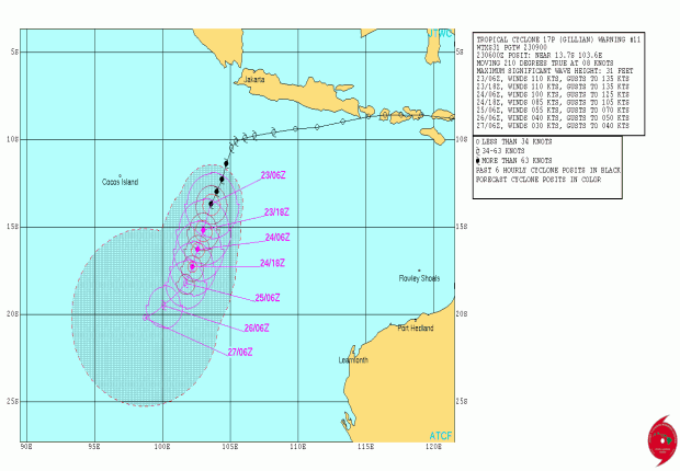
Finally I copied all the forecast information from the above Hurricane Zone Page and will paste all of it at the end of this blog entry. All of this will only be valid through Sunday, March 23, 2014 as new forecasts will be updated beginning throughout the day and of course into Monday. That link above may update, though! Thank-You for Reading!!! EQ Guy
WTXS31 PGTW 230900
MSGID/GENADMIN/JOINT TYPHOON WRNCEN PEARL HARBOR HI//
SUBJ/TROPICAL CYCLONE 17P (GILLIAN) WARNING NR 011//
RMKS/
1. TROPICAL CYCLONE 17P (GILLIAN) WARNING NR 011
01 ACTIVE TROPICAL CYCLONE IN SOUTHIO
MAX SUSTAINED WINDS BASED ON ONE-MINUTE AVERAGE
WIND RADII VALID OVER OPEN WATER ONLY
---
WARNING POSITION:
230600Z --- NEAR 13.7S 103.6E
MOVEMENT PAST SIX HOURS - 210 DEGREES AT 08 KTS
POSITION ACCURATE TO WITHIN 020 NM
POSITION BASED ON EYE FIXED BY SATELLITE
PRESENT WIND DISTRIBUTION:
MAX SUSTAINED WINDS - 110 KT, GUSTS 135 KT
WIND RADII VALID OVER OPEN WATER ONLY
RADIUS OF 064 KT WINDS - 035 NM NORTHEAST QUADRANT
040 NM SOUTHEAST QUADRANT
040 NM SOUTHWEST QUADRANT
035 NM NORTHWEST QUADRANT
RADIUS OF 050 KT WINDS - 065 NM NORTHEAST QUADRANT
070 NM SOUTHEAST QUADRANT
070 NM SOUTHWEST QUADRANT
065 NM NORTHWEST QUADRANT
RADIUS OF 034 KT WINDS - 110 NM NORTHEAST QUADRANT
120 NM SOUTHEAST QUADRANT
115 NM SOUTHWEST QUADRANT
105 NM NORTHWEST QUADRANT
REPEAT POSIT: 13.7S 103.6E
---
FORECASTS:
12 HRS, VALID AT:
231800Z --- 15.2S 103.0E
MAX SUSTAINED WINDS - 110 KT, GUSTS 135 KT
WIND RADII VALID OVER OPEN WATER ONLY
RADIUS OF 064 KT WINDS - 035 NM NORTHEAST QUADRANT
040 NM SOUTHEAST QUADRANT
040 NM SOUTHWEST QUADRANT
035 NM NORTHWEST QUADRANT
RADIUS OF 050 KT WINDS - 060 NM NORTHEAST QUADRANT
070 NM SOUTHEAST QUADRANT
070 NM SOUTHWEST QUADRANT
060 NM NORTHWEST QUADRANT
RADIUS OF 034 KT WINDS - 110 NM NORTHEAST QUADRANT
120 NM SOUTHEAST QUADRANT
115 NM SOUTHWEST QUADRANT
105 NM NORTHWEST QUADRANT
VECTOR TO 24 HR POSIT: 200 DEG/ 06 KTS
---
24 HRS, VALID AT:
240600Z --- 16.3S 102.6E
MAX SUSTAINED WINDS - 100 KT, GUSTS 125 KT
WIND RADII VALID OVER OPEN WATER ONLY
RADIUS OF 064 KT WINDS - 025 NM NORTHEAST QUADRANT
030 NM SOUTHEAST QUADRANT
030 NM SOUTHWEST QUADRANT
025 NM NORTHWEST QUADRANT
RADIUS OF 050 KT WINDS - 050 NM NORTHEAST QUADRANT
060 NM SOUTHEAST QUADRANT
060 NM SOUTHWEST QUADRANT
050 NM NORTHWEST QUADRANT
RADIUS OF 034 KT WINDS - 100 NM NORTHEAST QUADRANT
110 NM SOUTHEAST QUADRANT
105 NM SOUTHWEST QUADRANT
095 NM NORTHWEST QUADRANT
VECTOR TO 36 HR POSIT: 200 DEG/ 05 KTS
---
36 HRS, VALID AT:
241800Z --- 17.3S 102.2E
MAX SUSTAINED WINDS - 085 KT, GUSTS 105 KT
WIND RADII VALID OVER OPEN WATER ONLY
RADIUS OF 064 KT WINDS - 020 NM NORTHEAST QUADRANT
020 NM SOUTHEAST QUADRANT
020 NM SOUTHWEST QUADRANT
020 NM NORTHWEST QUADRANT
RADIUS OF 050 KT WINDS - 040 NM NORTHEAST QUADRANT
050 NM SOUTHEAST QUADRANT
050 NM SOUTHWEST QUADRANT
040 NM NORTHWEST QUADRANT
RADIUS OF 034 KT WINDS - 090 NM NORTHEAST QUADRANT
100 NM SOUTHEAST QUADRANT
095 NM SOUTHWEST QUADRANT
085 NM NORTHWEST QUADRANT
VECTOR TO 48 HR POSIT: 210 DEG/ 05 KTS
---
EXTENDED OUTLOOK:
48 HRS, VALID AT:
250600Z --- 18.2S 101.7E
MAX SUSTAINED WINDS - 055 KT, GUSTS 070 KT
WIND RADII VALID OVER OPEN WATER ONLY
RADIUS OF 050 KT WINDS - 030 NM NORTHEAST QUADRANT
040 NM SOUTHEAST QUADRANT
040 NM SOUTHWEST QUADRANT
030 NM NORTHWEST QUADRANT
RADIUS OF 034 KT WINDS - 080 NM NORTHEAST QUADRANT
090 NM SOUTHEAST QUADRANT
085 NM SOUTHWEST QUADRANT
075 NM NORTHWEST QUADRANT
VECTOR TO 72 HR POSIT: 230 DEG/ 05 KTS
---
72 HRS, VALID AT:
260600Z --- 19.5S 100.1E
MAX SUSTAINED WINDS - 040 KT, GUSTS 050 KT
WIND RADII VALID OVER OPEN WATER ONLY
DISSIPATING AS A SIGNIFICANT TROPICAL CYCLONE OVER WATER
RADIUS OF 034 KT WINDS - 070 NM NORTHEAST QUADRANT
080 NM SOUTHEAST QUADRANT
075 NM SOUTHWEST QUADRANT
065 NM NORTHWEST QUADRANT
VECTOR TO 96 HR POSIT: 240 DEG/ 04 KTS
---
LONG RANGE OUTLOOK:
---
96 HRS, VALID AT:
270600Z --- 20.2S 98.7E
MAX SUSTAINED WINDS - 030 KT, GUSTS 040 KT
WIND RADII VALID OVER OPEN WATER ONLY
DISSIPATED AS A SIGNIFICANT TROPICAL CYCLONE OVER WATER
---
REMARKS:
230900Z POSITION NEAR 14.1S 103.5E.
TROPICAL CYCLONE (TC) 17P (GILLIAN), LOCATED APPROXIMATELY 790 NM
NORTHWEST OF LEARMONTH, AUSTRALIA, HAS TRACKED SOUTH-SOUTHWESTWARD
AT 08 KNOTS OVER THE PAST SIX HOURS. ANIMATED MULTISPECTRAL
SATELLITE IMAGERY (MSI) REVEALS TC GILLION HAS CONTINUED TO RAPIDLY
DEEPEN INTO AN INTENSE SYSTEM AS THE CONVECTION HAS IMPROVED AROUND
A 15NM SLIGHTLY IRREGULAR EYE. A 230305Z TRMM MICROWAVE IMAGE SHOWS
A THICK RING OF DEEP CONVECTION IN THE EYEWALL WITH IMPROVED BANDING
IN ALL QUADRANTS. THE INITIAL POSITION IS BASED UPON THE EYE FEATURE
IN THE MSI LOOP WITH HIGH CONFIDENCE. THE INITIAL INTENSITY HAS BEEN
INCREASED TO 110 KTS BASED ON AVERAGE OF DVORAK INTENSITY ESTIMATES
THAT RANGE FROM 102 TO 115 KNOTS. UPPER-LEVEL ANALYSIS REVEALS A
FAVORABLE ENVIRONMENT AS A POINT SOURCE ANTICYCLONE HAS DEVELOPED
OVER THE SYSTEM WHICH IS PROVIDING LOW (05 TO 10 KNOTS) VERTICAL
WIND SHEAR (VWS) AND VIGOROUS POLEWARD AND EQUATORWARD OUTFLOW. TC
17P IS CURRENTLY TRACKING POLEWARD ALONG THE NORTHWESTERN PERIPHERY
OF A DEEP-LAYERED SUBTROPICAL RIDGE (STR) THAT POSITIONED TO THE
SOUTHEAST OF THE SYSTEM. TC GILLION IS EXPECTED TO CONTINUE ALONG
THIS STR THROUGH TAU 36 UNTIL A WEAK MID-LATITUDE TROUGH WELL TO THE
SOUTH WILL SLIGHTLY WEAKEN THE STR AND CAUSE THE CYCLONE TO SLOW
DOWN. AFTER TAU 24, A WEAKENING TREND IS EXPECTED TO BEGIN AS VWS
INCREASES FROM THE APPROACHING TROUGH. AFTER TAU 48, A SECONDARY STR
TRAILING THE TROUGH, WILL BUILD TO THE SOUTHWEST AND BEGIN TO MOVE A
WEAKENING TC 17P WESTWARD. VWS WILL GREATLY INCREASE AFTER TAU 48 AS
THE SYSTEM SWITCHES STEERING INFLUENCES AND WILL INDUCE A RAPID
WEAKENING TREND WHICH WILL DISSIPATE THE SYSTEM BELOW WARNING
THRESHOLD BY TAU 96. NUMERIC MODEL GUIDANCE IS SLIGHTLY SPREAD, BUT
WITH THE EXCEPTION OF COAMPS-TC AND NAVGEM, GENERALLY SUPPORTS THE
WESTWARD TRACK IN THE EXTENDED PERIOD. DUE TO THIS, THE JTWC
FORECAST TRACK IS POSITIONED CLOSE TO MULTI-MODEL CONSENSUS WITH LOW
CONFIDENCE. MAXIMUM SIGNIFICANT WAVE HEIGHT AT 230600Z IS 31 FEET.
NEXT WARNINGS AT 232100Z AND 240900Z.//
Friday, January 31, 2014
New EQ Podcast: Official Prediction for 9 Richters California!!!
CLICK Arrow and Listen!!! Thank-You!!! EQ Guy
Friday, January 24, 2014
EQ Podcast #001
My Very First Podcast!!!!! Check It Out!!! Click Arrow!!!
Thank-You For Listening!!!!! EQ Guy
Thank-You For Listening!!!!! EQ Guy
Monday, November 11, 2013
BIG EQ ALERT: BANGKOK, BANGLADESH, CHINA, INDONESIA!!! 7.9 to 9.1 RICHTERS!!!
This will be the next huge earthquake that strikes a fairly large area somewhere, although hopefully it will be a far less populated area without nearly the damage it could possibly do. There is also currently a similar alert that covers a lot of the same regions in the 7.6 to 8.1 Range and is on Day 31 as of November 11, 2013. THIS New EQ Alert will begin immediately and run through Mid-December.
The maximum windspeeds of Super Typhoon Haiyan were reported at 195 with gusts having been reported as high as 235mph by the JTWC prior to the landfall. Winds at landfall and beyond are being reported at 147 with gusts at 170 and it is probable there is not much difference there except that the amount of the higher numbers that were once reported also contribute to generating Major Earthquake Energy and as a result give us that highest estimated magnitude of 9.1 Richters.
The straight line from the landfall at Philippines heads directly across Thailand, Cambodia, Myanmar, Bangladesh, and Bangkok, but the entire tectonic plate boundary will also include up into China, Nepal, and a few other countries, and also south to Indonesia and the Andaman and Nicobar Islands Region. There has also now been a lot of shaking in the wake of that landfall, too, including one at Micronesia, and two very recent ones early today, November 11, 2013 at North of Taiwan, and Mariana Islands which looks like it's very near that Mariana Trench and all just 1500 or 2000 miles due east of the landfall of Super Typhoon Haiyan at Philippines.
The rule that I like to use and have written about in books and blogs, is that with the Major Earthquake Resultant expected after the landfall of a Huge Windstorm the damage will generally be about 90% of the damage done by the windstorm! In this case the damage from Super Typhoon Haiyan is now very extensive. . . and so we will be watching for the next huge Major Earthquake with damage similarly extensive and probably one comparable to what the Philippines is presently undergoing with Philippines even being very much in the crosshairs of this potential earthquake due to having just had a Major Earthquake in recent weeks and possibly being due for a Major or even larger aftershock near Cebu City.
There may be two of these gigantic sized Major Earthquakes due to strike and on at least one or two occasions they have combined which these two hopefully will not do. The Philippines also have a number of Major Volcanoes and as a result we might also expect some Volcano Activity, too! Thank-You For Reading!!! EQ Alert Guy
The maximum windspeeds of Super Typhoon Haiyan were reported at 195 with gusts having been reported as high as 235mph by the JTWC prior to the landfall. Winds at landfall and beyond are being reported at 147 with gusts at 170 and it is probable there is not much difference there except that the amount of the higher numbers that were once reported also contribute to generating Major Earthquake Energy and as a result give us that highest estimated magnitude of 9.1 Richters.
The straight line from the landfall at Philippines heads directly across Thailand, Cambodia, Myanmar, Bangladesh, and Bangkok, but the entire tectonic plate boundary will also include up into China, Nepal, and a few other countries, and also south to Indonesia and the Andaman and Nicobar Islands Region. There has also now been a lot of shaking in the wake of that landfall, too, including one at Micronesia, and two very recent ones early today, November 11, 2013 at North of Taiwan, and Mariana Islands which looks like it's very near that Mariana Trench and all just 1500 or 2000 miles due east of the landfall of Super Typhoon Haiyan at Philippines.
The rule that I like to use and have written about in books and blogs, is that with the Major Earthquake Resultant expected after the landfall of a Huge Windstorm the damage will generally be about 90% of the damage done by the windstorm! In this case the damage from Super Typhoon Haiyan is now very extensive. . . and so we will be watching for the next huge Major Earthquake with damage similarly extensive and probably one comparable to what the Philippines is presently undergoing with Philippines even being very much in the crosshairs of this potential earthquake due to having just had a Major Earthquake in recent weeks and possibly being due for a Major or even larger aftershock near Cebu City.
There may be two of these gigantic sized Major Earthquakes due to strike and on at least one or two occasions they have combined which these two hopefully will not do. The Philippines also have a number of Major Volcanoes and as a result we might also expect some Volcano Activity, too! Thank-You For Reading!!! EQ Alert Guy
Wednesday, September 18, 2013
OFFICIAL PREDICTION FOR A MAJOR EARTHQUAKE TO STRIKE ANCHORAGE, JUNEAU, HELENA, OR NEW MADRID BY OCTOBER 22, 2013
This brand new now upcoming Major Earthquake will probably be in the area of 6.7 or 6.8 Richters but could go as big as a 7.6 Richters. The area of uncertainty in magnitude is as a result of Typhoon Man-Yi losing strength as it approached landfall at Honshu Japan and the amount of possible seismic energy it could have generated in that approach in shallower waters and outlying islands as well as outer bands reaching land sooner, added to the total amount contacting the tectonic plate on land during Man-Yi’s landfall there.
There is also a Major Earthquake due to strike as soon as September 20 through 23 as a result of the landfall of big CAT-4 Super Typhoon Utor at the Philippines on August 11, 2013 which could possibly strike in the early days of this O.P. and could coincide with the September 2013 Full Moon Window of September 18 through September 20 and so a big South or Central America Earthquake of 7 or 8 Richters will not come under this Official Prediction if and when one does strike at any place other than those covered by this writing.
I had a similar Official Prediction written on October 14, 2012 that crossed a similar path and I stated Edmonton in that writing. . . . . and the huge climax actually occurred at Queen Charlotte Island just 13 days later at 7.7 on October 28, 2012. You can view that Official Prediction @ http://www.earthquakealert2.blogspot.com/2012/10/official-earthquake-prediction.html AND the USGS report on that Queen Charlotte Earthquake @ http://earthquake.usgs.gov/earthquakes/eqinthenews/2012/usb000df7n/
You could say that due to just the above rather recent incident regarding Jelawat, that we might know the landfall of Typhoon Man-Yi will probably now precede a quite similar Major Earthquake and possibly in that same region. One slight difference being the winds reported with Typhoon Jelawat at 100mph and Typhoon Man-Yi at 75, but you could also say that 75 percent of that 7.7 at Queen Charlotte might also still be a huge earthquake.
This straight line of brand new potential earthquake energy or seismic energy will now somewhat duplicate the path of the energy from that landfall of Typhoon Jelawat very near to where this recent landfall of Typhoon Man-Yi occurred. You can view the path of Jelawat at: http://en.wikipedia.org/wiki/File:Jelawat_2012_track.png and looks like it could stay south of the Denali Fault. I’m not sure which side of the Denali Fault Jelawat traveled but am reasonably sure todays path will be traveling south of it and the banner headline from the Jelawat O.P. says Fairbanks. Todays line crosses very near Anchorage and goes on to cross near the epicenter of 1964 Alaska Earthquake, then onto Juneau, Helena, and finally New Madrid and while I do not expect it to vary too much from this exact line, it does appear Queen Charlotte Island is situated a few miles west of the exact line of that October 14, 2012 O.P.
Today I am putting the final end date of all of this new earthquake energy at October 22, 2013, although a lot could happen in the days in between and those regions of Alaska that are situated closer to the Japan Landfall will be first along the line to possibly be affected. There is also as I write, an immediate chance Japan might get some of this earthquake energy as a result of all of the energy from this big windstorm pushing against Shikoku and Honshu and there was already a 5.1 Richters Earthquake at Honshu in the hours after that landfall. There could be more and it will remain a possibility that Japan could be affected and receive up to the grand total of 7.6 Richters at some point throughout the duration of this Official Prediction.
Thank-You Again for taking the time to read this O.P. and Thank-You also for all the great comments I have been getting when these major earthquakes inevitably strike such as the recent ones at Peru, Easter Island, and Victoria!!! Respectfully Submitted, EQ Guy
Herein Submitted September 18, 2013
There is also a Major Earthquake due to strike as soon as September 20 through 23 as a result of the landfall of big CAT-4 Super Typhoon Utor at the Philippines on August 11, 2013 which could possibly strike in the early days of this O.P. and could coincide with the September 2013 Full Moon Window of September 18 through September 20 and so a big South or Central America Earthquake of 7 or 8 Richters will not come under this Official Prediction if and when one does strike at any place other than those covered by this writing.
I had a similar Official Prediction written on October 14, 2012 that crossed a similar path and I stated Edmonton in that writing. . . . . and the huge climax actually occurred at Queen Charlotte Island just 13 days later at 7.7 on October 28, 2012. You can view that Official Prediction @ http://www.earthquakealert2.blogspot.com/2012/10/official-earthquake-prediction.html AND the USGS report on that Queen Charlotte Earthquake @ http://earthquake.usgs.gov/earthquakes/eqinthenews/2012/usb000df7n/
You could say that due to just the above rather recent incident regarding Jelawat, that we might know the landfall of Typhoon Man-Yi will probably now precede a quite similar Major Earthquake and possibly in that same region. One slight difference being the winds reported with Typhoon Jelawat at 100mph and Typhoon Man-Yi at 75, but you could also say that 75 percent of that 7.7 at Queen Charlotte might also still be a huge earthquake.
This straight line of brand new potential earthquake energy or seismic energy will now somewhat duplicate the path of the energy from that landfall of Typhoon Jelawat very near to where this recent landfall of Typhoon Man-Yi occurred. You can view the path of Jelawat at: http://en.wikipedia.org/wiki/File:Jelawat_2012_track.png and looks like it could stay south of the Denali Fault. I’m not sure which side of the Denali Fault Jelawat traveled but am reasonably sure todays path will be traveling south of it and the banner headline from the Jelawat O.P. says Fairbanks. Todays line crosses very near Anchorage and goes on to cross near the epicenter of 1964 Alaska Earthquake, then onto Juneau, Helena, and finally New Madrid and while I do not expect it to vary too much from this exact line, it does appear Queen Charlotte Island is situated a few miles west of the exact line of that October 14, 2012 O.P.

Today I am putting the final end date of all of this new earthquake energy at October 22, 2013, although a lot could happen in the days in between and those regions of Alaska that are situated closer to the Japan Landfall will be first along the line to possibly be affected. There is also as I write, an immediate chance Japan might get some of this earthquake energy as a result of all of the energy from this big windstorm pushing against Shikoku and Honshu and there was already a 5.1 Richters Earthquake at Honshu in the hours after that landfall. There could be more and it will remain a possibility that Japan could be affected and receive up to the grand total of 7.6 Richters at some point throughout the duration of this Official Prediction.
Thank-You Again for taking the time to read this O.P. and Thank-You also for all the great comments I have been getting when these major earthquakes inevitably strike such as the recent ones at Peru, Easter Island, and Victoria!!! Respectfully Submitted, EQ Guy
Herein Submitted September 18, 2013
Subscribe to:
Posts (Atom)